EuroVelo 10 & 13 / Visit Estonia
Die offizielle Website der estnischen Touristeninformation bietet detaillierte Informationen über die EuroVelo-Routen in Estland und touristische Dienstleistungen.
Diese EuroVelo GPX-Tracks werden unter der Open Database License zur Verfügung gestellt. Während ECF und die nationalen EuroVelo Koordinationszentren und Koordinatoren (NECCs) alle Anstrengungen unternehmen, um sicherzustellen, dass die Tracks und ihre Entwicklungsstufen sowohl sind, können Fehler oder veraltete Informationen auftreten. Der Benutzer ist ist für seine eigene Sicherheit bei der Nutzung der Strecken und für die für die Einhaltung der nationalen Verkehrsregeln und der Beschilderung. Bitte laden Sie die vollständige Lizenz und den Haftungsausschluss herunter und lesen Sie sie, bevor Sie die Tracks benutzen.
Bitte laden Sie die Anleitung zur Verwendung von GPX-Tracks und die vollständige Lizenz und Haftungsausschluss herunter und lesen Sie diese sorgfältig durch, bevor Sie die Tracks verwenden.
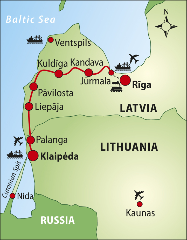
Die Etappe durch die Ostsee mag für EuroVelo 13 insgesamt relativ kurz sein, bietet aber ein bemerkenswert breites Spektrum an Landschaften, Kulturen und Geschichte sowie die Möglichkeit, drei Länder (und zwei Hauptstädte) hintereinander zu erkunden.
Obwohl während des Kalten Krieges auf dieser Strecke keine Mauer oder kein Zaun errichtet wurde, waren weite Teile der Küste militärische, unzugängliche Gebiete und wurden erst in den letzten Jahren wieder geöffnet. Tatsächlich verläuft die Route weitgehend entlang der attraktiven Küstenlinie. Es gibt viele Erinnerungen an die Zeit des Kalten Krieges, darunter Radargeräte, Militäranlagen und Denkmäler. Mit der Fähre erreichen Sie die Inseln Hiiumaa, Saaremaa und Muhu, bevor es zurück aufs Festland zur Küstenstadt Virtsu geht.
 Naturerbe
 Kulturelles Erbe
 Kulinarische Köstlichkeiten
 Martitimes Erbe / Der Rhein / Die Maas
 Anderer Ort von Interesse
 Service

Die offizielle Website der estnischen Touristeninformation bietet detaillierte Informationen über die EuroVelo-Routen in Estland und touristische Dienstleistungen.

Estland ist ein Paradies für Radfahrer. Hier finden Sie Einsamkeit in Wäldern, malerische Seen und Strände, an denen sich immer ein schöner Platz zum Campen findet. Die Größe Estlands ist ideal für Radfahrer, da man das ganze Land mit dem Rad erkunden kann. In nur wenigen Tagen können Sie die hügeligen Straßen des Südens erklimmen, einen Sonnenaufgang in den Mooren bewundern, historische und kulturelle Orte in Mittelestland und Tallinn besuchen, den Blick auf die Ostsee von der steilen, felsigen Nordküste genießen und die wilden Inseln – das beliebteste Ziel für Radfahrer – besuchen.
[email protected] +372 56608090
Das lettische Radinformationszentrum ist eine Radtourismusorganisation die 1991 in Riga gegründet wurde. Über die Jahre hinweg wurden viele heimischen und internationalen Radreisen organisiert, Radstrecken geplant und einiges unternommen, um die Popularität und Entwicklung von Fahrrädern und ihrer Kultur in Lettland voranzutreiben. Seit 1996 ist die Organisation der offizielle Partner des EuroVelo-Netzwerkes.
[email protected]
Litauen bietet eine flache Landschaft, kurze Entfernungen, Übersichtlichkeit und zahlreiche Möglichkeiten für ein Fahrradabenteuer: Legen Sie einen Badestopp ein, besuchen Sie einen Wakepark, machen Sie eine Stadtrundfahrt, steigen Sie auf ein Boot oder nehmen Sie eine Fähre – die Liste ist endlos. Entdecken Sie eines der unentdeckten Juwelen Nordeuropas – auf zwei Rädern!
[email protected] +370 619 29 795
Vidzeme, gelegen im Nordosten des Landes, ist eine der vier historischen Provinzen in Lettland. Ihr regionaler Tourismusverband ist für die Entwicklung der EuroVelo 13 in Lettland zuständig und informiert über die Route und die laufenden Arbeiten sowie über die Unterkunfts- und Radverkehrsaktivitäten in der Region.


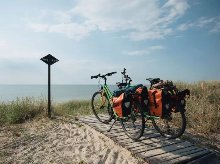
The perfumed air of untouched pine forests, the emerald sea as far as your eye can see and the majestic sand dunes of the Baltic coast – discover the cycling route of the Curonian Spit, your next cycling adventure that feels like a slow summer exhale.

Blend your next cycling adventure with a unique coastal holiday in the mesmerising Curonian Spit on the southeastern shores of the Baltic Sea. Nestled on a narrow strip of sea-swept white sand, this peaceful part of the EuroVelo network offers a memorable journey through the UNESCO World Heritage-l…


Was wäre, wenn wir Ihnen sagen würden, dass Sie auf den EuroVelo-Routen einige der bedeutendsten Wahrzeichen der europäischen Geschichte erradeln können? Entdecken Sie die Stätten des Europäischen Kulturerbe-Siegels entlang der mehr als 90.000 Kilometer des europäischen Radwegenetzes!

EuroVelo 13 - Iron Curtain Trail is one of the greatest challenges of the European cycle route network. This certified Cultural Route of the Council of Europe runs almost 10,000 kilometres along the former Iron Curtain from the Barents Sea to the Black Sea. German writer Rebecca Maria Salentin is t…


In December 1989, standing at Brandenburg Gate with the Berlin Wall coming down, Adam Koniuszewski, a student in Montreal, could not have imagined returning 35 years later by bicycle. Yet, on the 35th anniversary of the fall of the Berlin Wall on 9 November 2024, Adam was back for a momentous #Tear…


After several trips on EuroVelo routes over the last few years, Silvia Julian Gonzalez considers herself to be something of a EuroVelo collector. She spent the last summer on a fantastic adventure, travelling from Finland to Bretagne. Read her story from a summer full of memories.


Lynn Salvo does not shy away from a challenge. She is the oldest woman to cross North America from the Pacific to the Atlantic and North to South. This summer, she crossed the pond in search of a new adventure. After three months and countless challenges, she achieved her dream: becoming the oldest…

Dieses Radtourenbuch beschreibt EuroVelo-Routen in Finnland von Helsinki durch Russland und Estland (1.778 km). In Lettland sind 10 km bis Riga beschrieben. Perfekter Begleiter bei der Reisevorbereitung und unterwegs: präzise und sehr informative Karten im Maßstab 1:120.000 und 1:400.000, Höhen- und Streckenprofile, GPS-Tracks, Unterkunfts- und Serviceverzeichnis, LiveUpdate, Lenkertaschenformat, Spiralbindung, wetterfest und reißfest. Auch in englischer Sprache erhältlich.

Dieses Radtourenbuch beschreibt die EuroVelo 10 & EuroVelo 13 in Lettland von Riga, durch Litauen, Russland, Polen und in Deutschland bis Lübeck (1.604 km). In Lettland ist die Hälfte der Strecke beschrieben. Perfekter Begleiter bei der Reisevorbereitung und unterwegs: Karten im Maßstab 1:85.000, Höhen- und Streckenprofile, GPS-Tracks, Unterkunfts- und Serviceverzeichnis, LiveUpdate, Lenkertaschenformat, Spiralbindung, wetterfest und reißfest. Auch in englischer Sprache erhältlich.

Diese englischsprachige Broschüre stellt die Geschichte verschiedenster durch den Eisernen Vorhang getrennter Ländern vor. Mit ergänzenden Übersichtskarten und Streckenbeschreibungen aller Etappen des Iron Curtain Trail, ist diese Broschüre die perfekte Reisevorbereitung für die EuroVelo 13.
Die Broschüre „Litauen auf zwei Rädern“ bietet umfassende Informationen für Fahrradtouren durch Litauen. Sie enthält Details zu den Routen, Zielgruppen, für die die Radwege und Infrastruktur angepasst sind, Straßentypen (z. B. Schotter, Radwege), Sehenswürdigkeiten, Transportdienste, Verleihstationen und weitere wichtige Informationen.

Das Programm „Cyclist Welcome“ in Estland soll Radreisenden den Aufenthalt in Unterkünften erleichtern. Von „Cyclist Welcome” zertifizierte Unternehmen heißen Radtouristen willkommen und bieten ihnen einen sicheren Abstellraum für ihre Fahrräder, eine Standpumpe und grundlegende Werkzeuge, eine Ladestation sowie Informationen zu Radwegen und Dienstleistungen für Radfahrer in der Region. Diese zertifizierten Unterkünfte stehen Ihnen auch gerne mit Ideen zur Verfügung, wie Sie Ihren Radurlaub verlängern, einen zusätzlichen Zwischenstopp einlegen, sich entspannen und mehr vom lokalen Leben entdecken können.
Die offizielle Tourismus-Website „visit estonia“ bietet eine interaktive Karte, auf der sowohl Radwege als auch Unterkünfte, Naturparks, Sehenswürdigkeiten und vieles mehr angezeigt werden.