EuroVelo-GPX-Tracks in Routenplanungs- und Navigations-Apps nutzen: Ein Vergleich
Anmerkung vom Januar 2026: Der EuroVelo-Routenplaner ermöglicht nun auch das Herunterladen einzigartiger und durchgehender GPX-Tracks, die mit den meisten Navigations-Apps verwendet werden können und die Planung Ihrer Reise auf EuroVelo-Routen erleichtern. Weitere Details finden Sie in diesem Artikel.

Wenn du dich zwischen Komovelo, RidewithYou, WikiAnd, NaviTrails und der großen Anzahl an verfügbaren Routenplanungs- und Navigations-Apps verloren fühlst, wird dir dieser Artikel nicht sagen, welche App die beste ist. Er zeigt dir jedoch, wie EuroVelo-Tracks in verschiedenen Apps dargestellt werden und welche Zusatzinformationen zu den Routen jeweils verfügbar sind. Wir haben EuroVelo-Tracks auf 9 Websites/Apps und einer Computer-Software getestet und berichten hier über unsere Ergebnisse. Außerdem kannst du dir diesen Artikel aus dem Jahr 2022 ansehen.
Bitte beachte, dass reine Routenfindungs-Apps wie GeoVelo nicht Teil dieser Analyse sind, da sie keinen Import externer GPX-Tracks ermöglichen.
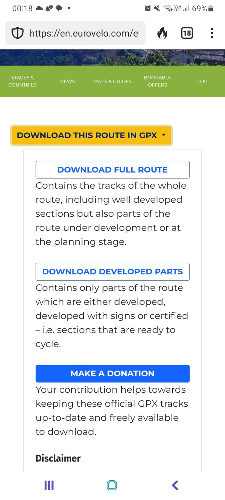
Zunächst ein paar technische Grundlagen: EuroVelo-GPX-Tracks können kostenlos auf www.EuroVelo.com heruntergeladen werden, sowohl von allgemeinen Routenseiten (z. B. hier oder hier) als auch von thematischen Etappenseiten (z. B. hier oder hier). Klicke auf „Download this stage in GPX“, worauf sich ein Feld öffnet, in dem du zwischen „Download full route/stage“ und „Download developed parts“ wählen kannst. Wir empfehlen die zweite Option, um sicherzugehen, dass du auf bereits realisierten Routen unterwegs bist. Wenn du jedoch abenteuerlustig bist, bieten die „full route/stage“-Tracks in weniger entwickelten Abschnitten des Netzes derzeit die beste verfügbare Option.
Das Download-Feld lädt dich außerdem ein, eine Spende zu leisten, um unsere Arbeit als gemeinnützige Initiative zu unterstützen. Vergiss nicht, unseren Haftungsausschluss zu lesen, der wichtige Informationen zur Lizenz der EuroVelo-GPX-Tracks (jetzt die Open Data Commons Open Database License), zu ihrer Nutzung und zu ihren Einschränkungen enthält.
Zusätzlich können EuroVelo-GPX-Tracks auch über das Tool EuroVelo-Routenplaner heruntergeladen werden, nachdem du dort deine eigene Route mit EuroVelo-Strecken erstellt hast. Probiere es einfach aus!
EuroVelo-Tracks liegen im .gpx-Format vor und bestehen aus mehreren Teilstrecken von jeweils etwa 50 km – den sogenannten „Tagesetappen“. Informationen zum Entwicklungsstand jeder Etappe sind im Namen der jeweiligen Strecke enthalten. Es ist wichtig, diese Angaben zu prüfen, um zu wissen, was dich erwartet: Ist die Infrastruktur fahrradgerecht? Gibt es eine EuroVelo-Beschilderung entlang der Strecke?
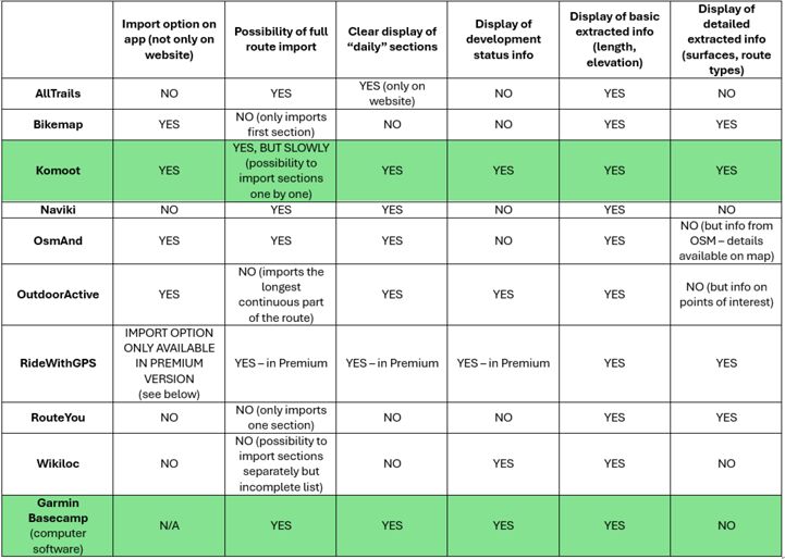
Nun sind deine EuroVelo-GPX-Tracks auf deinem Computer oder Smartphone gespeichert – und genau hier wird es oft knifflig. Wie kann man sie anzeigen und unterwegs nutzen? Dafür musst du die GPX-Datei in eine geeignete App oder Software hochladen. Um dir den Einstieg zu erleichtern, findest du hier eine Übersicht unserer Testergebnisse mit einigen der beliebtesten Routenplanungs- und Navigations-Apps. Wenn du mehr Details möchtest, scrolle weiter nach unten zu den ausführlichen Einzelbewertungen.

AllTrails
Der Import von GPX-Tracks ist nur über die AllTrails-Website möglich, danach sind sie in der App verfügbar. Die komplette Strecke wird hochgeladen, auch mehrere nicht zusammenhängende Segmente werden korrekt verarbeitet. Informationen zum Entwicklungsstand der einzelnen Abschnitte werden jedoch nicht angezeigt.
Bikemap
GPX-Tracks können sowohl auf der Bikemap-Website als auch in der App importiert werden. Leider werden Routen mit mehreren getrennten Segmenten nicht unterstützt. Es wird nur der erste Abschnitt der Route importiert, was Bikemap für die Planung von EuroVelo-Reisen nur eingeschränkt nutzbar macht.
Komoot

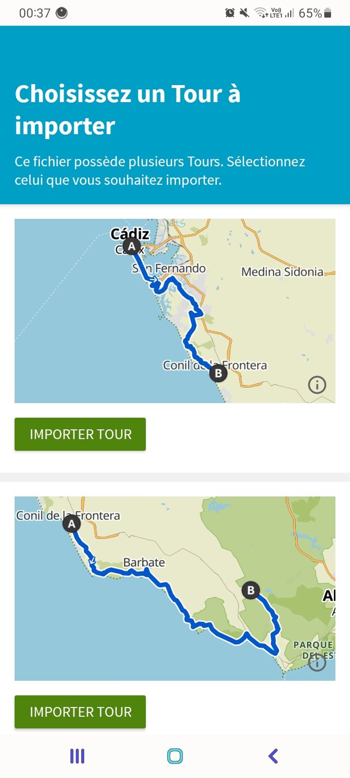
Der GPX-Import ist sowohl auf der Komoot-Website als auch in der App möglich. Komoot eignet sich gut für die Planung von EuroVelo-Reisen: Der Entwicklungsstand wird im Titel jeder importierten Etappe angezeigt, und es stehen viele detaillierte Informationen zur Verfügung, die automatisch aus OpenStreetMap übernommen werden, etwa zu Infrastruktur- und Oberflächenarten. Ein Nachteil ist, dass jede Tagesetappe einzeln importiert werden muss, was bei langen Routen zeitaufwendig sein kann. Andererseits erleichtert dies die Auswahl einzelner Teilstrecken.
Naviki
Der Import von GPX-Tracks erfolgt über die Naviki-Website, danach sind die Tracks in der App verfügbar. Die komplette Route wird hochgeladen, auch mit mehreren getrennten Segmenten. Informationen zum Entwicklungsstand der einzelnen Abschnitte werden jedoch nicht angezeigt.
OsmAnd

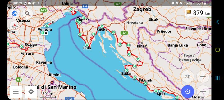
OsmAnd ist ausschließlich als App verfügbar und direkt mit der OpenStreetMap-Datenbank verbunden. GPX-Tracks können in der App hochgeladen werden, und auch komplette EuroVelo-Routen mit mehreren Segmenten werden korrekt dargestellt. Informationen zum Entwicklungsstand der einzelnen Abschnitte fehlen jedoch.
OutdoorActive
GPX-Tracks können sowohl auf der OutdoorActive-Website als auch in der App importiert werden. Routen mit mehreren getrennten Segmenten werden allerdings nicht unterstützt. Das System importiert automatisch den längsten zusammenhängenden Abschnitt, bricht jedoch bei Unterbrechungen ab (z. B. Meeresüberquerungen oder nicht exakt anschließenden Segmenten). Für die EuroVelo-Planung ist OutdoorActive daher nur bedingt geeignet, es sei denn, man teilt die Route vorher in kürzere, zusammenhängende Abschnitte (z. B. mit Garmin Basecamp). Positiv ist die große Auswahl an vorgeschlagenen Sehenswürdigkeiten entlang der Route.
Ride with GPS
Der Import von GPX-Tracks ist nur mit dem RideWithGPS Premium-Routenplaner möglich. Dieser erlaubt es, EuroVelo-GPX-Tracks umfassend zu bearbeiten und alle relevanten Daten zu nutzen. Das Unternehmen hat sogar Anleitungen und ein Video-Tutorial dazu veröffentlicht. Bitte beachte, dass wir die Premium-Versionen anderer Apps nicht getestet haben.
RouteYou
Der Import von GPX-Tracks erfolgt über die RouteYou-Website, anschließend sind sie in der App verfügbar. Routen mit mehreren getrennten Segmenten werden nicht unterstützt, und es wird nur ein einzelner Abschnitt importiert. Das erschwert die Nutzung für die Planung längerer EuroVelo-Reisen.
Wikiloc
Der GPX-Import ist über die Wikiloc-Website möglich, danach sind die Tracks in der App verfügbar. Die Website erlaubt die Auswahl einzelner Segmente, diese entsprechen jedoch nicht den offiziellen Tagesetappen, und einige Abschnitte fehlen. Das macht Wikiloc für die EuroVelo-Planung etwas umständlich. Positiv ist, dass der Entwicklungsstand im Titel der importierten Segmente angezeigt wird.
Garmin Basecamp
Garmin Basecamp ist eine reine Desktop-Software und sehr hilfreich zur Bearbeitung von GPX-Tracks. Die Tracks lassen sich problemlos auf Garmin-Geräte übertragen. Basecamp eignet sich hervorragend zur Visualisierung von EuroVelo-GPX-Tracks und zur Anzeige des Entwicklungsstands der einzelnen Etappen. Mit etwas technischem Know-how kannst du Tracks auch schneiden und kombinieren, um deine individuelle EuroVelo-Reise zu planen.
Geschrieben von Florence Grégoire
Titelbild: Jay Miller auf Unsplash